ISO 7010:2019 / ISO 3864-1
ISO W085 Typhoon/hurricane/cyclone zone Sign
ISO W085 Typhoon/hurricane/cyclone zone Sign means the exposure of the area to typhoons, hurricanes, or tropical cyclones — the same intense rotating storm named by ocean basin. ISO 7010 W085 flags standing regional risk so residents and visitors prepare and evacuate early, with landfall warnings themselves coming from meteorological agencies. It should be used where the cited standard, facility risk assessment, SDS, emergency plan, or written safety procedure requires this hazard or safety message to be communicated.
High-Res Viewer
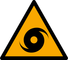
Reference artwork: Wikimedia Commons · License: CC0

Technical Data
| Legal Standard | ISO 7010:2019 / ISO 3864-1 |
|---|---|
| Color Codes | #FFCC00 / RAL 1003 Signal Yellow |
| Viewing Distance | 50 mm: close equipment or package label; 100 mm: approximately 5 m; 200 mm: approximately 10 m; 300 mm: approximately 15 m; 400 mm: approximately 20 m. |
| Review Status | approved / last reviewed 2026-07-07 |
| Jurisdiction Scope | Global, United States, European Union |
| Keywords | w085, iso 7010, warning, typhoon, hurricane, cyclone, zone, warn, potential |
Standard Dimensions Table
| Sign Size | Recommended Visibility |
|---|---|
50 mm | close equipment or package label |
100 mm | approximately 5 m |
200 mm | approximately 10 m |
300 mm | approximately 15 m |
400 mm | approximately 20 m. |
Where This Sign Is Used
Coastal municipalities, island and harbor authorities, and resort or marina operators post it at seafronts, ferry terminals, campgrounds, and beach access points in basins with recurring storm seasons, where high visitor turnover makes a translation-free symbol most valuable. Surge-exposed shorelines pair it with E062 evacuation-area and E063 vertical-evacuation-building signs, while inland shelters carry E065, and supplementary panels add shelter locations, evacuation zone designations, and official warning channels.
In-Depth Guidance
One Sign for Three Storm Names
W085 warns of a potential typhoon, hurricane, or cyclone in the area. The three names describe the same phenomenon — an intense rotating tropical storm — labeled by ocean basin: typhoons in the northwest Pacific, hurricanes in the Atlantic and northeast Pacific, tropical cyclones in the Indian Ocean and South Pacific. ISO 7010 deliberately folds all three into one symbol so a single pictogram reads correctly from Okinawa to Florida to Queensland.
The sign belongs to the natural-hazard zone series added to ISO 7010 by amendment, an internationalization of the disaster-signage practice Japan developed for tsunamis and codified in the ISO 22578 tradition — fitting, since Japan itself absorbs several typhoon landfalls in a typical year. Like its siblings, it flags standing regional exposure; landfall warnings come from meteorological agencies days in advance, not from street signage.
What Makes Tropical Cyclone Zones Distinct
A tropical cyclone is a compound disaster. Extreme winds strip roofs and turn loose objects into projectiles, torrential rainfall drives river flooding and landslides far inland, and storm surge — the wind-pushed dome of seawater that arrives with landfall — inundates low coastal ground and is historically the deadliest component. A W085 zone therefore overlaps naturally with W077 flood zones and W078 landslide zones, and coastal installations often sit near storm-surge inundation markers.
Unlike a tornado or debris flow, a tropical storm gives long lead time, which changes the sign's implied action from take cover now to prepare and evacuate early. The populations that most need the reminder are those without local storm experience: tourists on tropical coasts, seasonal workers, and new residents who have never boarded a window or read a surge map.
Posting and Pairing in Practice
Coastal municipalities, island and harbor authorities, and resort or marina operators are the natural users of W085 — at seafronts, ferry terminals, campgrounds, and beach access points in basins with recurring tropical storm seasons. The symbol's value is greatest where visitor turnover is high and multilingual: it condenses the message that this coast takes direct hits into a form that needs no translation.
The evacuation counterparts complete the system. Surge-exposed shorelines connect the warning to E062, the evacuation-area sign for designated high ground, and E063, the sign for vertical-evacuation buildings, while inland shelters carry E065, the natural disaster refuge symbol. Supplementary panels typically add the locally relevant specifics: shelter locations, evacuation zone letters or numbers, and where to hear official storm advisories.
Acting on a W085 Zone
If you live or stay in a marked zone, the preparation checklist is stable across basins: learn whether your address or accommodation sits in a surge evacuation zone, identify the designated shelter or inland route, keep enough water, food, and power for several days, and secure or bring in anything wind can lift. When an evacuation order is issued for your zone, leave early — roads, ferries, and airports degrade quickly as the storm closes in.
Two behaviors cause a disproportionate share of tropical-storm deaths and injuries: staying in surge-prone ground-floor locations near the water, and going outside during the calm eye, which is followed by the storm's second half from the opposite direction. Pre-event signage exists precisely to seed this knowledge in people who will one day hear a landfall warning with only days to act on it.
Frequently Asked Questions
What is the difference between a typhoon, a hurricane, and a cyclone?
Nothing except geography. All are tropical cyclones — rotating storms with sustained winds above the same intensity threshold — called typhoons in the northwest Pacific, hurricanes in the Atlantic and northeast Pacific, and cyclones in the Indian Ocean and South Pacific. ISO 7010 W085 uses one symbol for all three so the warning reads identically worldwide.
What does a W085 sign tell me to do?
It tells you the coast or region experiences tropical storms, so you should prepare before one is forecast: find out if you are in a storm-surge evacuation zone, locate the designated shelter or high ground, and know where official advisories are issued. During an actual storm threat, follow the meteorological agency's warnings and any evacuation orders, which arrive with days of lead time.
Is storm surge really more dangerous than the wind?
Historically yes. The seawater pushed ashore at landfall has caused most tropical-cyclone deaths, because it floods low coastal ground quickly and with immense force. This is why W085 installations on exposed shorelines pair with evacuation signage such as E062 and E063, and why evacuation zones are drawn around surge maps rather than wind fields.
Why put up a cyclone zone sign when forecasts give days of warning?
Because forecasts only help people who know what to do with them. Tourists, seasonal workers, and new residents often have no storm experience, do not know their evacuation zone, and underestimate surge. A permanent zone sign plants that awareness ahead of time, so the eventual warning triggers prepared action instead of confusion.